Geolocate

Felix topographic map

Click on the map to display elevation.

About this map

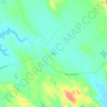
Name: Felix topographic map, elevation, terrain.

Location: Felix, Calaveras County, California, United States (38.00826 -120.73576 38.04826 -120.69576)

Average elevation: 349 m

Minimum elevation: 322 m

Maximum elevation: 419 m

Gear up for your next adventure:

🧦Thermal Socks - Warm socks for winter hiking or camping
🧢Beanie Hat - Keep your head warm in cold weather
🧰Emergency Multi-Tool - Compact multi-tool for outdoor survival
Bushcraft Tarp - Versatile emergency shelter or gear protection
🔥Emergency Fire Starter - Reliable ignition source for all weather conditions

As an Amazon Associate, this site earns from qualifying purchases at no extra cost to you.