
Make a donation
Gear up for your next adventure:
As an Amazon Associate, this site earns from qualifying purchases at no extra cost to you.
Star Valley topographic map
Click on the map to display elevation.
Make a donation
Gear up for your next adventure:
As an Amazon Associate, this site earns from qualifying purchases at no extra cost to you.
Star Valley
According to the United States Census Bureau, the town has a total area of 36.1 square miles (93.6 km2), of which 0.01 square miles (0.02 km2), or 0.03%, is water. Star Valley sits at an elevation of 4,650 feet (1,420 m) and takes its name from the valley in which it is located, formed by Houston Creek, which descends to the south through Tonto National Forest to Tonto Creek, a tributary of the Salt River. The town was incorporated as the Town of Diamond Star, but changed its name to Star Valley in 2006.
Make a donation
Gear up for your next adventure:
As an Amazon Associate, this site earns from qualifying purchases at no extra cost to you.
About this map
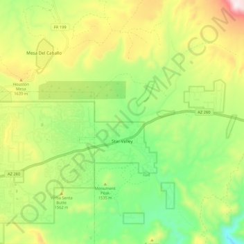
Name: Star Valley topographic map, elevation, terrain.
Location: Star Valley, Gila County, Arizona, United States (34.21713 -111.27992 34.30436 -111.20321)
Average elevation: 1,521 m
Minimum elevation: 1,221 m
Maximum elevation: 1,933 m
Make a donation
Gear up for your next adventure:
As an Amazon Associate, this site earns from qualifying purchases at no extra cost to you.