
Valsaín topographic map
Click on the map to display elevation.
Valsaín
Valsaín está dentro del término municipal de Real Sitio de San Ildefonso, tiene una población de 183 habitantes (INE 2022) y se sitúa a una altitud de 1180 metros. Ubicado en la vertiente segoviana de la sierra de Guadarrama, a 50 km de Madrid, 8 de Segovia y 2 de La Granja, en un área de bosque a tres kilómetros de la localidad de San Ildefonso.
About this map
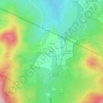
Name: Valsaín topographic map, elevation, terrain.
Average elevation: 1,256 m
Minimum elevation: 1,104 m
Maximum elevation: 1,535 m
Other topographic maps
Click on a map to view its topography, its elevation and its terrain.
Valsaín
España > Castilla y León > Real Sitio de San Ildefonso
Valsaín está dentro del término municipal de Real Sitio de San Ildefonso, tiene una población de 183 habitantes (INE 2022) y se sitúa a una altitud de 1180 metros. Ubicado en la vertiente segoviana de la sierra de Guadarrama, a 50 km de Madrid, 8 de Segovia y 2 de La Granja, en un área de bosque a tres…
Average elevation: 1,579 m
Peñas Lisas
España > Castilla y León > Real Sitio de San Ildefonso > Valsaín
Average elevation: 1,352 m
Embalse del Pontón Alto
España > Castilla y León > Real Sitio de San Ildefonso > La Granja > Valsaín
Average elevation: 1,130 m