
Mattituck topographic map
Interactive map
Click on the map to display elevation.
About this map
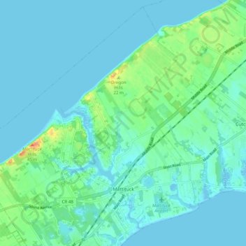
Name: Mattituck topographic map, elevation, terrain.
Average elevation: 8 m
Minimum elevation: -4 m
Maximum elevation: 41 m
Other topographic maps
Click on a map to view its topography, its elevation and its terrain.
Fishers Island
United States > New York > Suffolk County > Town of Southold
Fishers Island, Town of Southold, Suffolk County, New York, 06390, United States
Average elevation: 0 m
New Suffolk
United States > New York > Suffolk County > Town of Southold
New Suffolk, Town of Southold, Suffolk County, New York, 11956, United States
Average elevation: 2 m
Cutchogue
United States > New York > Suffolk County > Town of Southold
Cutchogue, Town of Southold, Suffolk County, New York, 11935, United States
Average elevation: 7 m
East Marion
United States > New York > Suffolk County > Town of Southold
East Marion, Town of Southold, Suffolk County, New York, 11939, United States
Average elevation: 4 m
Orient
United States > New York > Suffolk County > Town of Southold
Orient, Town of Southold, Suffolk County, New York, United States
Average elevation: 2 m