
Make a donation
Gear up for your next adventure:
As an Amazon Associate, this site earns from qualifying purchases at no extra cost to you.
Baranello topographic map
Click on the map to display elevation.
Make a donation
Gear up for your next adventure:
As an Amazon Associate, this site earns from qualifying purchases at no extra cost to you.
About this map
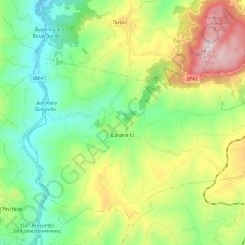
Name: Baranello topographic map, elevation, terrain.
Location: Baranello, Campobasso, Molise, 86011, Italia (41.50214 14.52580 41.55672 14.61324)
Average elevation: 626 m
Minimum elevation: 411 m
Maximum elevation: 987 m
Make a donation
Gear up for your next adventure:
As an Amazon Associate, this site earns from qualifying purchases at no extra cost to you.
Other topographic maps
Click on a map to view its topography, its elevation and its terrain.
Make a donation
Gear up for your next adventure:
As an Amazon Associate, this site earns from qualifying purchases at no extra cost to you.
Make a donation
Gear up for your next adventure:
As an Amazon Associate, this site earns from qualifying purchases at no extra cost to you.
Decontra di Sant'Angelo Limosano
Italia > Molise > Campobasso > Sant'Angelo Limosano
Average elevation: 759 m