
Houffalize topographic map
Interactive map
Click on the map to display elevation.
About this map
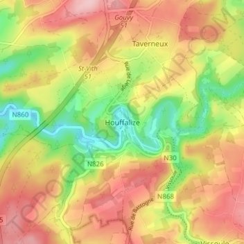
Name: Houffalize topographic map, elevation, terrain.
Location: Houffalize, Bastenaken, Luxemburg, Wallonië, België (50.11238 5.76869 50.15238 5.80869)
Average elevation: 405 m
Minimum elevation: 317 m
Maximum elevation: 480 m
Other topographic maps
Click on a map to view its topography, its elevation and its terrain.
Tavigny
België > Luxemburg > Bastenaken > Houffalize
Tavigny, Houffalize, Bastenaken, Luxemburg, Wallonië, 6662, België
Average elevation: 460 m
Fin de Ville
België > Luxemburg > Bastenaken > Houffalize
Fin de Ville, Houffalize, Bastenaken, Luxemburg, Wallonië, 6660, België
Average elevation: 403 m