
Make a donation
Gear up for your next adventure:
As an Amazon Associate, this site earns from qualifying purchases at no extra cost to you.
Leiler-Berg topographic map
Click on the map to display elevation.
Make a donation
Gear up for your next adventure:
As an Amazon Associate, this site earns from qualifying purchases at no extra cost to you.
About this map
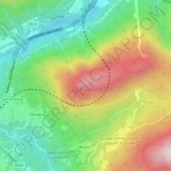
Name: Leiler-Berg topographic map, elevation, terrain.
Average elevation: 878 m
Minimum elevation: 627 m
Maximum elevation: 1,238 m
Make a donation
Gear up for your next adventure:
As an Amazon Associate, this site earns from qualifying purchases at no extra cost to you.
Other topographic maps
Click on a map to view its topography, its elevation and its terrain.
Gailitz
Italien > Friaul-Julisch Venetien > Udine > Tarvis
Der Ursprung der Gailitz, dort am Oberlauf Rio Lago oder Seebach genannt, liegt im Seebachtal unterhalb des Nevea-Sattels in Italien. Sie durchfließt den Raibler See (Lago di Predil) unterhalb des Predilpasses (1156 m s.l.m.). Anschließend fließt sie nach Norden, an Tarvis vorbei, wo sie den Rio Bartolo…
Average elevation: 950 m