
Thank you for supporting this site ❤️
Make a donation
Make a donation
Gear up for your next adventure:
As an Amazon Associate, this site earns from qualifying purchases at no extra cost to you.
Truckee topographic map
Click on the map to display elevation.
Thank you for supporting this site ❤️
Make a donation
Make a donation
Gear up for your next adventure:
As an Amazon Associate, this site earns from qualifying purchases at no extra cost to you.
About this map
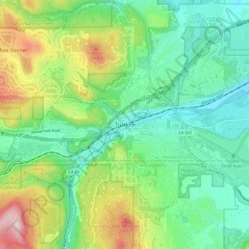
Name: Truckee topographic map, elevation, terrain.
Location: Truckee, Nevada County, California, 96161, United States (39.28796 -120.22325 39.36796 -120.14325)
Average elevation: 1,859 m
Minimum elevation: 1,734 m
Maximum elevation: 2,140 m
Thank you for supporting this site ❤️
Make a donation
Make a donation
Gear up for your next adventure:
As an Amazon Associate, this site earns from qualifying purchases at no extra cost to you.
Other topographic maps
Click on a map to view its topography, its elevation and its terrain.
Prosser Creek Reservoir
United States > California > Nevada County > Truckee
Average elevation: 1,763 m