
Make a donation
Gear up for your next adventure:
As an Amazon Associate, this site earns from qualifying purchases at no extra cost to you.
Corinth topographic map
Click on the map to display elevation.
Make a donation
Gear up for your next adventure:
As an Amazon Associate, this site earns from qualifying purchases at no extra cost to you.
About this map
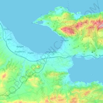
Name: Corinth topographic map, elevation, terrain.
Average elevation: 185 m
Minimum elevation: -3 m
Maximum elevation: 1,356 m
Make a donation
Gear up for your next adventure:
As an Amazon Associate, this site earns from qualifying purchases at no extra cost to you.
Other topographic maps
Click on a map to view its topography, its elevation and its terrain.
Corinth
Greece > Peloponnese, Western Greece and the Ionian > Corinthia Regional Unit
Average elevation: 21 m
Municipal Unit of Saronikos
Greece > Peloponnese, Western Greece and the Ionian > Corinthia Regional Unit
Average elevation: 445 m
Corinth
Greece > Peloponnese, Western Greece and the Ionian > Corinthia Regional Unit
Average elevation: 21 m
Municipal Unit of Agioi Theodoroi
Greece > Peloponnese, Western Greece and the Ionian > Corinthia Regional Unit
Average elevation: 372 m
Make a donation
Gear up for your next adventure:
As an Amazon Associate, this site earns from qualifying purchases at no extra cost to you.
Municipal Unit of Velos
Greece > Peloponnese, Western Greece and the Ionian > Corinthia Regional Unit
Average elevation: 276 m
Corinth Canal
Greece > Peloponnese, Western Greece and the Ionian > Corinthia Regional Unit > Municipal Unit of Loutraki - Perachora > Γαλότα
Average elevation: 61 m
Municipal Unit of Corinth
Greece > Peloponnese, Western Greece and the Ionian > Corinthia Regional Unit
Average elevation: 126 m
Municipal Unit of Evrostina
Greece > Peloponnese, Western Greece and the Ionian > Corinthia Regional Unit
Average elevation: 699 m
Make a donation
Gear up for your next adventure:
As an Amazon Associate, this site earns from qualifying purchases at no extra cost to you.
Municipal Unit of Assos - Lechaio
Greece > Peloponnese, Western Greece and the Ionian > Corinthia Regional Unit
Average elevation: 131 m
Municipal Unit of Loutraki - Perachora
Greece > Peloponnese, Western Greece and the Ionian > Corinthia Regional Unit
Average elevation: 170 m
Community of Ano Trikala
Greece > Peloponnese, Western Greece and the Ionian > Corinthia Regional Unit > Municipal Unit of Xylokastro
Average elevation: 1,551 m