
Make a donation
Gear up for your next adventure:
As an Amazon Associate, this site earns from qualifying purchases at no extra cost to you.
Melsbroek topographic map
Click on the map to display elevation.
Make a donation
Gear up for your next adventure:
As an Amazon Associate, this site earns from qualifying purchases at no extra cost to you.
Melsbroek
Melsbroek ligt in Zandlemig Vlaanderen en de hoogte varieert tussen 15 en 40 meter. Een groot deel van de oppervlakte wordt ingenomen door het vliegveld. De omgeving is toch al sterk verstedelijkt en kent ook drukke autowegen van en naar de stad Brussel. Ten noorden van het dorp loopt de Barebeek.
Make a donation
Gear up for your next adventure:
As an Amazon Associate, this site earns from qualifying purchases at no extra cost to you.
About this map
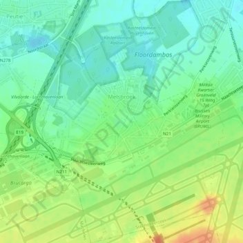
Name: Melsbroek topographic map, elevation, terrain.
Average elevation: 26 m
Minimum elevation: 9 m
Maximum elevation: 51 m
Make a donation
Gear up for your next adventure:
As an Amazon Associate, this site earns from qualifying purchases at no extra cost to you.
Other topographic maps
Click on a map to view its topography, its elevation and its terrain.