
San Luis topographic map
Interactive map
Click on the map to display elevation.
About this map
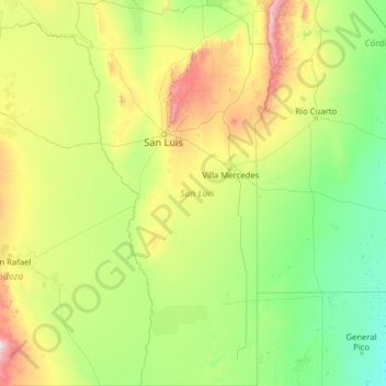
Name: San Luis topographic map, elevation, terrain.
Location: San Luis, Argentina (-36.00063 -67.47610 -31.83380 -64.88275)
Average elevation: 492 m
Minimum elevation: 114 m
Maximum elevation: 3,132 m
Other topographic maps
Click on a map to view its topography, its elevation and its terrain.
Villa Larca
Villa Larca, Comisión Municipal de Villa Larca, Chacabuco, San Luis, Argentina
Average elevation: 1,068 m
Municipio de San Luis
Municipio de San Luis, Juan Martín de Pueyrredón, San Luis, Argentina
Average elevation: 734 m