Geolocate

Tartu topographic map

Click on the map to display elevation.

About this map

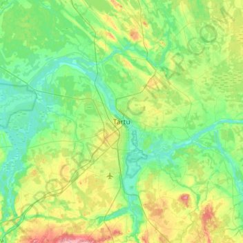
Name: Tartu topographic map, elevation, terrain.

Location: Tartu, Tartu linn, Tartu maakond, 53007, Estonia (58.22012 26.56245 58.54012 26.88245)

Average elevation: 55 m

Minimum elevation: 27 m

Maximum elevation: 135 m

Gear up for your next adventure:

🥾Lightweight Hiking Boots - Boots for comfort and mobility on long hikes
🛰️Satellite Messenger - Emergency communication for areas with no cell service
🥾Light Trekking Boots - Supportive boots for multi-day treks
🥾Mountaineering Boots - Supportive boots for climbing and high-altitude hiking
💡LED Camping Lantern - Illuminate your campsite with long-lasting lanterns

As an Amazon Associate, this site earns from qualifying purchases at no extra cost to you.