
Thank you for supporting this site ❤️
Make a donation
Make a donation
Gear up for your next adventure:
As an Amazon Associate, this site earns from qualifying purchases at no extra cost to you.
A-Do-Barriga topographic map
Click on the map to display elevation.
Thank you for supporting this site ❤️
Make a donation
Make a donation
Gear up for your next adventure:
As an Amazon Associate, this site earns from qualifying purchases at no extra cost to you.
About this map
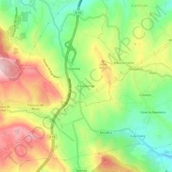
Name: A-Do-Barriga topographic map, elevation, terrain.
Location: A-Do-Barriga, Arruda dos Vinhos, Lisboa, 2600-817, Portugal (38.93836 -9.07696 38.97836 -9.03696)
Average elevation: 199 m
Minimum elevation: 58 m
Maximum elevation: 367 m
Thank you for supporting this site ❤️
Make a donation
Make a donation
Gear up for your next adventure:
As an Amazon Associate, this site earns from qualifying purchases at no extra cost to you.
Other topographic maps
Click on a map to view its topography, its elevation and its terrain.
Forte da Carvalha
Portugal > Lisboa > Arruda dos Vinhos > S. Tiago dos Velhos > Carvalha
Average elevation: 288 m