Geolocate

Mabuhay topographic map

Click on the map to display elevation.

About this map

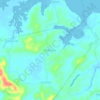
Name: Mabuhay topographic map, elevation, terrain.

Location: Mabuhay, Dapa, Surigao del Norte, Caraga, 8417, Philippines (9.80767 126.08921 9.84767 126.12921)

Average elevation: 17 m

Minimum elevation: 0 m

Maximum elevation: 107 m

Other topographic maps

Click on a map to view its topography, its elevation and its terrain.

Corregidor

Philippines > Surigao Del Norte > Dapa

Average elevation: 3 m

Pagaspas

Philippines > Surigao Del Norte > Dapa

Average elevation: 16 m

Pagaspas

Philippines > Surigao Del Norte > Dapa

Average elevation: 16 m

Gear up for your next adventure:

📷Outdoor Action Camera - Capture high-elevation views and rugged adventures
Camping Tent - Weather-resistant tents suitable for 2 to 6 people
🌬️Windproof Camp Stove - Efficient cooking even on exposed mountain peaks
🧦Crew Hiking Socks - Comfortable socks for long-distance hikes
🥾Waterproof Hiking Boots - Essential footwear for rugged terrain and wet Canadian trails

As an Amazon Associate, this site earns from qualifying purchases at no extra cost to you.