Geolocate

Maldevta topographic map

Click on the map to display elevation.

About this map

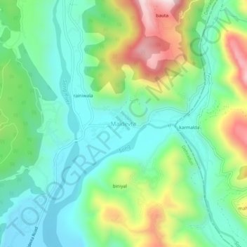
Name: Maldevta topographic map, elevation, terrain.

Location: Maldevta, Dehradun, Uttarakhand, 248013, India (30.32424 78.10379 30.36424 78.14379)

Average elevation: 850 m

Minimum elevation: 671 m

Maximum elevation: 1,246 m

Gear up for your next adventure:

🥾Lightweight Hiking Shoes - Comfortable shoes for day hikes
Bushcraft Tarp - Versatile emergency shelter or gear protection
🧥Fleece Jacket - Warm and lightweight jacket for layering
🏕️Camping Hammock - Integrated protection for sleeping between trees
🥾Trail Hiking Socks - Comfortable socks to prevent blisters and fatigue

As an Amazon Associate, this site earns from qualifying purchases at no extra cost to you.