Geolocate

Rauco topographic map

Click on the map to display elevation.

About this map

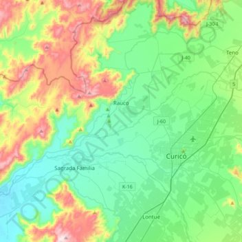
Name: Rauco topographic map, elevation, terrain.

Location: Rauco, Provincia de Curicó, Maule Region, Chile (-35.05767 -71.59871 -34.83303 -71.26027)

Average elevation: 300 m

Minimum elevation: 114 m

Maximum elevation: 778 m

Gear up for your next adventure:

💡Compact LED Flashlight - Powerful and portable flashlight for outdoor use
🧥Softshell Jacket - Windproof and breathable jacket for hiking
🛶Canoe Life Vest - Safety vest for water sports
🪜Heavy Duty Carabiners - Multi-use clips for securing gear to your backpack
🚲Bike Repair Kit - Essential tools for on-trail mechanical issues

As an Amazon Associate, this site earns from qualifying purchases at no extra cost to you.