Geolocate

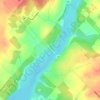
Dracon topographic map

Click on the map to display elevation.

About this map

Name: Dracon topographic map, elevation, terrain.

Location: Dracon, Centre Wellington, Wellington County, Southwestern Ontario, Ontario, N0B 1J0, Canada (43.80935 -80.39288 43.82935 -80.37288)

Average elevation: 463 m

Minimum elevation: 447 m

Maximum elevation: 478 m

Other topographic maps

Click on a map to view its topography, its elevation and its terrain.
Gear up for your next adventure:

🐕Hiking Dog Pack - Let your canine companion carry their own water and food
⛺Tent Footprint - Protect tent floor and increase durability
🧤Insulated Winter Gloves - Heavy-duty protection for sub-zero Canadian adventures
🧢Hiking Sun Hat - Wide-brimmed protection for exposed mountain ridges
🧥Ultralight Puffy Jacket - Maximum warmth that packs down to the size of an orange

As an Amazon Associate, this site earns from qualifying purchases at no extra cost to you.