Geolocate

Soest topographic map

Click on the map to display elevation.

About this map
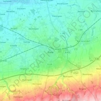
Name: Soest topographic map, elevation, terrain.

Location: Soest, Kreis Soest, North Rhine-Westphalia, 59494, Germany (51.52147 7.98314 51.62756 8.17620)

Average elevation: 121 m

Minimum elevation: 67 m

Maximum elevation: 268 m

Other topographic maps

Click on a map to view its topography, its elevation and its terrain.

Wester

Germany > North Rhine-Westphalia > Kreis Soest > Warstein > Belecke

Average elevation: 308 m

Körbecke

Germany > North Rhine-Westphalia > Kreis Soest

Average elevation: 249 m

Gear up for your next adventure:

🥾Approach Shoes - Shoes designed for climbing approaches and rugged trails
🦶Anti-Blister Balm - Prevents friction and hotspots during long ascents
🚲Bike Repair Kit - Essential tools for on-trail mechanical issues
🕯️Camping Lantern - Illuminates your entire campsite with high-efficiency LEDs
🦯Trekking Poles - Reduced impact on joints for steep topographic climbs

As an Amazon Associate, this site earns from qualifying purchases at no extra cost to you.