Geolocate

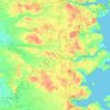
Kolding topographic map

Click on the map to display elevation.

About this map
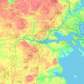
Name: Kolding topographic map, elevation, terrain.

Location: Kolding, Kolding Municipality, Region of Southern Denmark, 6000, Denmark (55.32950 9.31905 55.64950 9.63905)

Average elevation: 39 m

Minimum elevation: -4 m

Maximum elevation: 104 m

Other topographic maps

Click on a map to view its topography, its elevation and its terrain.

Funen

Denmark > Region of Southern Denmark

Average elevation: 19 m

Funen

Denmark > Region of Southern Denmark

Average elevation: 19 m

Funen

Denmark > Region of Southern Denmark

Average elevation: 19 m

Funen

Denmark > Region of Southern Denmark

Average elevation: 19 m

Rømø

Denmark > Region of Southern Denmark

Average elevation: 0 m

Skarø

Denmark > Region of Southern Denmark

Average elevation: 0 m

Guldbjerg

Denmark > Region of Southern Denmark

Average elevation: 23 m

Egholm

Denmark > Region of Southern Denmark

Average elevation: 0 m

Funen

Denmark > Region of Southern Denmark

Average elevation: 19 m

Funen

Denmark > Region of Southern Denmark

Average elevation: 19 m

Ærø

Denmark > Region of Southern Denmark

Average elevation: 3 m

Gear up for your next adventure:

🧦Hiking Socks - Moisture-wicking and comfortable socks for long hikes
🥾Hiking Leggings - Comfortable leggings for outdoor activities
🥾Approach Boots - Comfortable boots for hiking and climbing approaches
🛌Insulated Sleeping Pad - Critical thermal barrier between you and the cold ground
🧢Sun Protection Cap - Breathable cap to protect from sun exposure

As an Amazon Associate, this site earns from qualifying purchases at no extra cost to you.