
Hachénoi topographic map
Interactive map
Click on the map to display elevation.
About this map
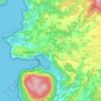
Name: Hachénoi topographic map, elevation, terrain.
Location: Hachénoi, Tsingoni, Mayotte, 97680, France (-12.80916 45.09285 -12.76916 45.13285)
Average elevation: 71 m
Minimum elevation: 0 m
Maximum elevation: 214 m
Other topographic maps
Click on a map to view its topography, its elevation and its terrain.