
Make a donation
Gear up for your next adventure:
As an Amazon Associate, this site earns from qualifying purchases at no extra cost to you.
Wolfsberg topographic map
Click on the map to display elevation.
Make a donation
Gear up for your next adventure:
As an Amazon Associate, this site earns from qualifying purchases at no extra cost to you.
About this map
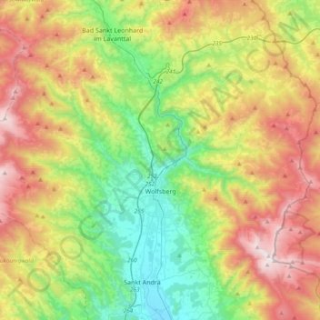
Name: Wolfsberg topographic map, elevation, terrain.
Location: Wolfsberg, Bezirk Wolfsberg, Carinthia, 9400, Austria (46.77540 14.64074 46.95154 15.01561)
Average elevation: 1,062 m
Minimum elevation: 386 m
Maximum elevation: 2,117 m
Make a donation
Gear up for your next adventure:
As an Amazon Associate, this site earns from qualifying purchases at no extra cost to you.
Other topographic maps
Click on a map to view its topography, its elevation and its terrain.
Hintergumitsch
Austria > Carinthia > Bezirk Wolfsberg > Frantschach-Sankt Gertraud
Average elevation: 662 m
Schiefling
Austria > Carinthia > Bezirk Wolfsberg > Bad Sankt Leonhard im Lavanttal
Average elevation: 849 m
Wartkogel
Austria > Carinthia > Bezirk Wolfsberg > Bad Sankt Leonhard im Lavanttal
Average elevation: 964 m
Make a donation
Gear up for your next adventure:
As an Amazon Associate, this site earns from qualifying purchases at no extra cost to you.