Geolocate

Urdilde topographic map

Click on the map to display elevation.

About this map

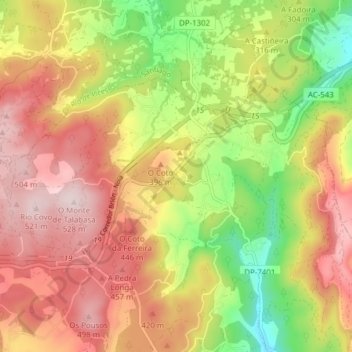
Name: Urdilde topographic map, elevation, terrain.

Location: Urdilde, A Calle, Rois, Sar, La Coruña, Galicia, España (42.80676 -8.77872 42.84314 -8.69855)

Average elevation: 332 m

Minimum elevation: 96 m

Maximum elevation: 524 m

Other topographic maps

Click on a map to view its topography, its elevation and its terrain.

Pedre

España > Galicia > Sar > A Calle

Average elevation: 269 m

Gear up for your next adventure:

💡LED Headlamp - Hands-free illumination for night hiking and camping
🧦Merino Wool Socks - Moisture-wicking comfort for long-distance hiking
🥘Camping Cookware Set - Compact nesting pots and pans for trail cooking
🧰Survival Kit - Essential gear for emergencies in the wilderness
🥾Approach Boots - Comfortable boots for hiking and climbing approaches

As an Amazon Associate, this site earns from qualifying purchases at no extra cost to you.