Geolocate

Wellsford topographic map

Click on the map to display elevation.

About this map

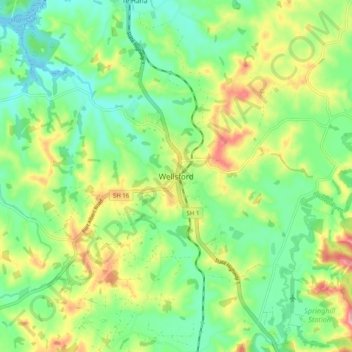
Name: Wellsford topographic map, elevation, terrain.

Location: Wellsford, Rodney, Auckland, 0900, New Zealand (-36.33574 174.48326 -36.25574 174.56326)

Average elevation: 56 m

Minimum elevation: 0 m

Maximum elevation: 155 m

Other topographic maps

Click on a map to view its topography, its elevation and its terrain.

Helensville

New Zealand > Auckland > Rodney

Average elevation: 21 m

Dome Forest

New Zealand > Auckland > Rodney

Average elevation: 168 m

Cowan Bay

New Zealand > Auckland > Rodney > Snells Beach

Average elevation: 22 m

Lake Rototoa

New Zealand > Auckland > Rodney

Average elevation: 102 m

Taupaki Estate

New Zealand > Auckland > Rodney > Kumeū

Average elevation: 37 m

Omaha Beach

New Zealand > Auckland > Rodney > Omaha

Average elevation: 3 m

Gear up for your next adventure:

🔋Emergency Crank Radio - Weather alerts and power without needing batteries
🛶Kayak Dry Bag - Waterproof storage for kayaking adventures
🔋Solar Power Bank - Keep your GPS and devices charged during long outdoor trips
🧥Softshell Hiking Jacket - The perfect balance of wind protection and breathability
🥾Mountain Hiking Shoes - Shoes with superior grip for mountainous terrain

As an Amazon Associate, this site earns from qualifying purchases at no extra cost to you.