Geolocate

Bertogne topographic map

Click on the map to display elevation.

About this map

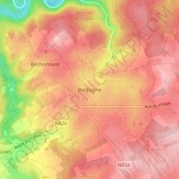
Name: Bertogne topographic map, elevation, terrain.

Location: Bertogne, Bastogne, Luxembourg, Wallonia, 6687, Belgium (50.06433 5.64761 50.10433 5.68761)

Average elevation: 424 m

Minimum elevation: 292 m

Maximum elevation: 489 m

Other topographic maps

Click on a map to view its topography, its elevation and its terrain.

Noville

Belgium > Luxembourg > Bastogne > Bastogne

Average elevation: 472 m

Flamierge

Belgium > Luxembourg > Bastogne > Bastogne

Average elevation: 429 m

Gear up for your next adventure:

🚲Heavy Duty Bike Lock - Secure your bike at the trailhead or during stops
🧴Waterproofing Spray - Restore the DWR coating on jackets and tents
🧥Softshell Jacket - Windproof and breathable jacket for hiking
Camping Essentials - All-in-one gear for a comfortable camping trip
🕶️Polarized Sunglasses - Protect your eyes with durable polarized lenses

As an Amazon Associate, this site earns from qualifying purchases at no extra cost to you.