Geolocate

Tröpolach topographic map

Click on the map to display elevation.

About this map

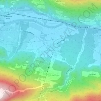
Name: Tröpolach topographic map, elevation, terrain.

Location: Tröpolach, Hermagor, Carinthia, 9631, Austria (46.59290 13.25823 46.63290 13.29823)

Average elevation: 769 m

Minimum elevation: 589 m

Maximum elevation: 1,396 m

Gear up for your next adventure:

Backpacking Tent - Lightweight tent for long-distance hiking trips
🔨Vehicle Emergency Tool - Safety tool for remote road trips to trailheads
🦌Outdoor Trail Camera - Monitor wildlife activity near your favorite spots
🥾Mountaineering Boots - Supportive boots for climbing and high-altitude hiking
🧣Evaporative Cooling Towel - Beat the heat during intense summer climbs

As an Amazon Associate, this site earns from qualifying purchases at no extra cost to you.