Geolocate

Jombang topographic map

Click on the map to display elevation.

About this map

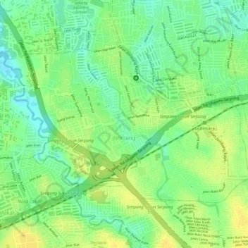
Name: Jombang topographic map, elevation, terrain.

Location: Jombang, Ciputat, South Tangerang, Banten, Java, Indonesia (-6.30568 106.69045 -6.28837 106.71789)

Average elevation: 40 m

Minimum elevation: 25 m

Maximum elevation: 51 m

Other topographic maps

Click on a map to view its topography, its elevation and its terrain.

BSD

Indonesia > Banten > South Tangerang

Average elevation: 33 m

Rengas

Indonesia > Banten > South Tangerang

Average elevation: 36 m

Provence Suites

Indonesia > Banten > South Tangerang

Average elevation: 34 m

Taman Provence

Indonesia > Banten > South Tangerang

Average elevation: 34 m

Ciater

Indonesia > Banten > South Tangerang

Average elevation: 42 m

Gear up for your next adventure:

🧢Beanie Hat - Keep your head warm in cold weather
🧥Waterproof Jacket - Lightweight rain jackets for hiking and outdoor activities
💡Compact LED Flashlight - Powerful and portable flashlight for outdoor use
🎒Backpack Rain Cover - External shield to keep your entire pack dry
💧Filtered Water Bottle - Safe drinking water on the go

As an Amazon Associate, this site earns from qualifying purchases at no extra cost to you.