Geolocate

Kenmore topographic map

Click on the map to display elevation.

About this map

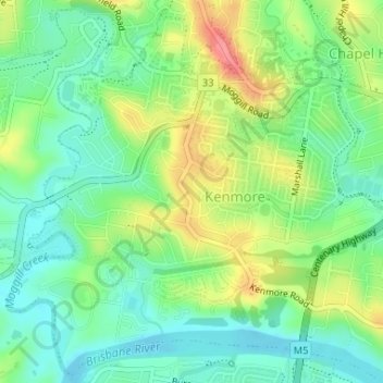
Name: Kenmore topographic map, elevation, terrain.

Location: Kenmore, Brisbane City, Queensland, 4069, Australia (-27.52954 152.92193 -27.50174 152.95461)

Average elevation: 30 m

Minimum elevation: 0 m

Maximum elevation: 82 m

Other topographic maps

Click on a map to view its topography, its elevation and its terrain.

Willmington Park

Australia > Queensland > Brisbane City

Average elevation: 37 m

Mount Gravatt

Australia > Queensland > Brisbane City

Average elevation: 70 m

Ithaca

Australia > Queensland > Brisbane City > Ithaca

Average elevation: 31 m

Gear up for your next adventure:

🧢Outdoor Cap - Protective cap for sun and rain during hikes
❄️Traction Ice Cleats - Slip-on spikes for icy trails and winter hiking
👟Trail Running Shoes - Agile footwear for fast-paced topographic exploration
🔥Camping Stove - Portable stoves to cook outdoors with ease
🔪Outdoor Multitool - Versatile tool for repairs and food prep in the wild

As an Amazon Associate, this site earns from qualifying purchases at no extra cost to you.