Geolocate

Sunderland topographic map

Click on the map to display elevation.

About this map
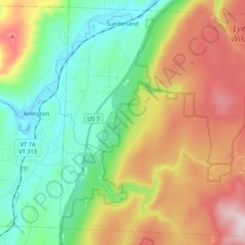
Name: Sunderland topographic map, elevation, terrain.

Location: Sunderland, Bennington County, Vermont, 05252, United States (43.02146 -73.14059 43.12053 -72.99732)

Average elevation: 500 m

Minimum elevation: 179 m

Maximum elevation: 1,036 m

Other topographic maps

Click on a map to view its topography, its elevation and its terrain.

North Pownal

United States > Vermont > Bennington County

Average elevation: 254 m

South Dorset

United States > Vermont > Bennington County

Average elevation: 377 m

Bondville

United States > Vermont > Bennington County > Winhall

Average elevation: 486 m

Bondville

United States > Vermont > Bennington County > Winhall

Average elevation: 486 m

South Dorset

United States > Vermont > Bennington County

Average elevation: 377 m

Gear up for your next adventure:

🥾Hiking Boots - Sturdy boots providing ankle support and traction on rugged trails
⛺Family Camping Tent - Spacious tent suitable for family camping trips
🧦Hiking Liner Socks - Thin base layer to prevent friction and blisters
🛶Kayak Dry Bag - Waterproof storage for kayaking adventures
💡LED Headlamp - Hands-free illumination for night hiking and camping

As an Amazon Associate, this site earns from qualifying purchases at no extra cost to you.