Geolocate

Mildenau topographic map

Click on the map to display elevation.

About this map

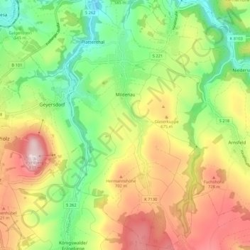
Name: Mildenau topographic map, elevation, terrain.

Location: Mildenau, Erzgebirgskreis, Saxony, Germany (50.54906 13.04485 50.61573 13.15023)

Average elevation: 606 m

Minimum elevation: 424 m

Maximum elevation: 835 m

Other topographic maps

Click on a map to view its topography, its elevation and its terrain.

Gear up for your next adventure:

👟Trail Running Shoes - Agile footwear for fast-paced topographic exploration
🛏️Camping Sleeping Mat - Comfortable mats for sleeping outdoors
🎒Hiking Daypack - Lightweight and durable backpacks for day trips and excursions
💡LED Camping Lantern - Illuminate your campsite with long-lasting lanterns
🔦LED Flashlight - Powerful and long-lasting flashlight for camping and emergencies

As an Amazon Associate, this site earns from qualifying purchases at no extra cost to you.