
Thank you for supporting this site ❤️
Make a donation
Make a donation
Gear up for your next adventure:
As an Amazon Associate, this site earns from qualifying purchases at no extra cost to you.
`Irq topographic map
Click on the map to display elevation.
Thank you for supporting this site ❤️
Make a donation
Make a donation
Gear up for your next adventure:
As an Amazon Associate, this site earns from qualifying purchases at no extra cost to you.
About this map
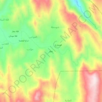
Name: `Irq topographic map, elevation, terrain.
Location: `Irq, Mu'thib, Ghamr district, Sa'dah Governorate, Yemen (16.96332 43.34321 17.00332 43.38321)
Average elevation: 1,752 m
Minimum elevation: 1,502 m
Maximum elevation: 2,014 m
Thank you for supporting this site ❤️
Make a donation
Make a donation
Gear up for your next adventure:
As an Amazon Associate, this site earns from qualifying purchases at no extra cost to you.