Geolocate

Talladega topographic map

Click on the map to display elevation.

About this map

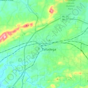
Name: Talladega topographic map, elevation, terrain.

Location: Talladega, Talladega County, Alabama, United States (33.39244 -86.16040 33.47085 -86.04872)

Average elevation: 191 m

Minimum elevation: 143 m

Maximum elevation: 374 m

Other topographic maps

Click on a map to view its topography, its elevation and its terrain.

Dry Valley

United States > Alabama > Talladega County > Lincoln

Average elevation: 173 m

Bethlehem

United States > Alabama > Talladega County

Average elevation: 187 m

Walco

United States > Alabama > Talladega County > Sylacauga

Average elevation: 173 m

Munford

United States > Alabama > Talladega County > Munford

Average elevation: 191 m

Saint Ives

United States > Alabama > Talladega County

Average elevation: 157 m

The Moon

United States > Alabama > Talladega County > Sylacauga

Average elevation: 199 m

Gear up for your next adventure:

🧢Hiking Hat - Sun-protective and breathable hats for long treks
🥾Hiking Gaiters - Protect legs and shoes from mud, snow, and debris
💧Reusable Water Bottle - Durable water bottles for hydration on trails
🧴Bear Spray Holster - Quick-access carry for essential Canadian wilderness safety
🧭Orienteering Kit - Tools for map reading and navigation in the wild

As an Amazon Associate, this site earns from qualifying purchases at no extra cost to you.