
Thank you for supporting this site ❤️
Make a donation
Make a donation
Gear up for your next adventure:
As an Amazon Associate, this site earns from qualifying purchases at no extra cost to you.
Temal topographic map
Click on the map to display elevation.
Thank you for supporting this site ❤️
Make a donation
Make a donation
Gear up for your next adventure:
As an Amazon Associate, this site earns from qualifying purchases at no extra cost to you.
About this map
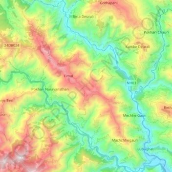
Name: Temal topographic map, elevation, terrain.
Location: Temal, Kavrepalanchok, Bagmati Pradesh, Nepal (27.43819 85.69137 27.58458 85.82091)
Average elevation: 1,176 m
Minimum elevation: 523 m
Maximum elevation: 2,280 m
Thank you for supporting this site ❤️
Make a donation
Make a donation
Gear up for your next adventure:
As an Amazon Associate, this site earns from qualifying purchases at no extra cost to you.