
Hailey topographic map
Interactive map
Click on the map to display elevation.
About this map
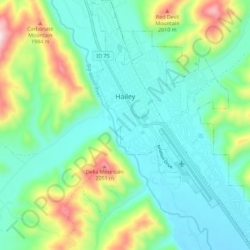
Name: Hailey topographic map, elevation, terrain.
Location: Hailey, Blaine County, Idaho, 83333, United States (43.48422 -114.32597 43.54215 -114.26708)
Average elevation: 1,729 m
Minimum elevation: 1,589 m
Maximum elevation: 2,115 m
Hailey is located at 43°30′54″N 114°18′23″W / 43.51500°N 114.30639°W / 43.51500; -114.30639 (43.514937, -114.306251), at an elevation of 5,318 feet (1,621 m) above sea level.
Other topographic maps
Click on a map to view its topography, its elevation and its terrain.
Carey
United States > Idaho > Blaine County
Carey, Blaine County, Idaho, 83320, United States
Average elevation: 1,467 m
Sun Valley
United States > Idaho > Blaine County
Sun Valley, Blaine County, Idaho, United States
Average elevation: 1,988 m
Ketchum
United States > Idaho > Blaine County
Ketchum, Blaine County, Idaho, United States
Average elevation: 1,906 m
Titus Lake
United States > Idaho > Blaine County
Titus Lake, Blaine County, Idaho, United States
Average elevation: 2,736 m
Bellevue
United States > Idaho > Blaine County
Bellevue, Blaine County, Idaho, 83313, United States
Average elevation: 1,667 m