
Caen topographic map
Interactive map
Click on the map to display elevation.
About this map
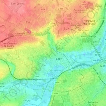
Name: Caen topographic map, elevation, terrain.
Location: Caen, Calvados, Normandy, Metropolitan France, 14000, France (49.15301 -0.41378 49.21627 -0.33073)
Average elevation: 35 m
Minimum elevation: -1 m
Maximum elevation: 81 m
Other topographic maps
Click on a map to view its topography, its elevation and its terrain.
Le Domaine
France > Normandy > Calvados > Vire Normandie > Le Domaine
Le Domaine, Coulonces, Vire Normandie, Vire, Calvados, Normandy, Metropolitan France, 14500, France
Average elevation: 157 m
Saint-Lambert
Saint-Lambert, Caen, Calvados, Normandy, Metropolitan France, 14570, France
Average elevation: 180 m
Repentigny
Repentigny, Lisieux, Calvados, Normandy, Metropolitan France, 14340, France
Average elevation: 89 m
Sainte-Honorine-de-Ducy
Sainte-Honorine-de-Ducy, Bayeux, Calvados, Normandy, Metropolitan France, 14240, France
Average elevation: 134 m
Le Mesnil-Patry
France > Normandy > Calvados > Thue et Mue
Le Mesnil-Patry, Thue et Mue, Caen, Calvados, Normandy, Metropolitan France, 14740, France
Average elevation: 80 m
Sept-Vents
France > Normandy > Calvados > Val de Drôme
Sept-Vents, Val de Drôme, Vire, Calvados, Normandy, Metropolitan France, 14240, France
Average elevation: 141 m