Geolocate

Lisieux topographic map

Click on the map to display elevation.

About this map

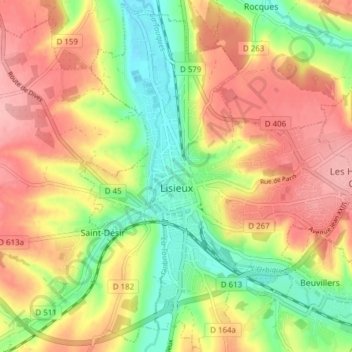
Name: Lisieux topographic map, elevation, terrain.

Location: Lisieux, Calvados, Normandy, Metropolitan France, 14100, France (49.12322 0.20441 49.17225 0.28090)

Average elevation: 97 m

Minimum elevation: 34 m

Maximum elevation: 156 m

Other topographic maps

Click on a map to view its topography, its elevation and its terrain.

Le Domaine

France > Normandy > Calvados > Vire Normandie > Le Domaine

Average elevation: 157 m

Gear up for your next adventure:

🥽Outdoor Goggles - Protective eyewear for outdoor activities
🛌Down Sleeping Bag - Superior warmth-to-weight ratio for cold nights
🧴Sunscreen SPF - Broad-spectrum sunscreen for outdoor activities
🧼Biodegradable Camp Soap - Environmentally friendly cleaning for gear and body
🎒Backpack Rain Cover - External shield to keep your entire pack dry

As an Amazon Associate, this site earns from qualifying purchases at no extra cost to you.