Geolocate

Juja Farm topographic map

Click on the map to display elevation.

About this map

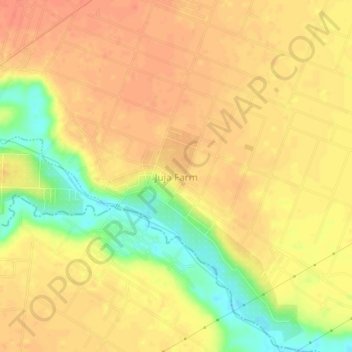
Name: Juja Farm topographic map, elevation, terrain.

Location: Juja Farm, Kalimoni ward, Juja, Kiambu, Kenya (-1.18623 37.06957 -1.14623 37.10957)

Average elevation: 1,472 m

Minimum elevation: 1,441 m

Maximum elevation: 1,486 m

Gear up for your next adventure:

👟Sport Hiking Sandals - Breathable footwear for water crossings and camp rest
🧦Thermal Socks - Warm socks for winter hiking or camping
🎒Hiking Daypack - Lightweight and durable backpacks for day trips and excursions
💧Filtered Water Bottle - Safe drinking water on the go
🥾Approach Boots - Comfortable boots for hiking and climbing approaches

As an Amazon Associate, this site earns from qualifying purchases at no extra cost to you.