
Make a donation
Gear up for your next adventure:
As an Amazon Associate, this site earns from qualifying purchases at no extra cost to you.
Bottelare topographic map
Click on the map to display elevation.
Make a donation
Gear up for your next adventure:
As an Amazon Associate, this site earns from qualifying purchases at no extra cost to you.
Bottelare
Bottelare ligt in zandlemig Vlaanderen op een hoogte van omstreeks 30 meter. In het noorden vindt men het Gentbos en in het westen de Makegemse bossen. In het zuidoosten stroomt de Driesbeek die naar het noordoosten stroomt en uitmondt in de Gondelbeek. Langs de Driesbeek ligt het natuurgebied Driesbeekvallei met onder meer de Bottelaarse Vijvers.
Make a donation
Gear up for your next adventure:
As an Amazon Associate, this site earns from qualifying purchases at no extra cost to you.
About this map
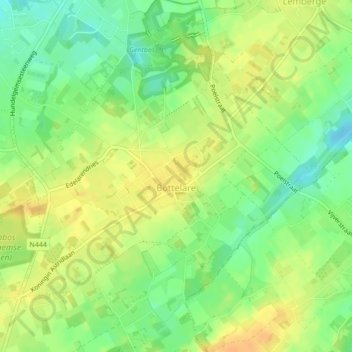
Name: Bottelare topographic map, elevation, terrain.
Location: Bottelare, Merelbeke, Gent, Oost-Vlaanderen, België (50.95513 3.73622 50.97375 3.77244)
Average elevation: 26 m
Minimum elevation: 9 m
Maximum elevation: 40 m
Make a donation
Gear up for your next adventure:
As an Amazon Associate, this site earns from qualifying purchases at no extra cost to you.
Other topographic maps
Click on a map to view its topography, its elevation and its terrain.
Makegembos / Harentbeekbos / Bruinbos (Makegemse Bossen)
België > Oost-Vlaanderen > Gent > Merelbeke > Schelderode
Average elevation: 29 m