
Make a donation
Gear up for your next adventure:
As an Amazon Associate, this site earns from qualifying purchases at no extra cost to you.
Logan Canyon topographic map
Click on the map to display elevation.
Make a donation
Gear up for your next adventure:
As an Amazon Associate, this site earns from qualifying purchases at no extra cost to you.
Logan Canyon
Logan Canyon is a canyon in the western United States in northeastern Utah, which cuts its way through the Bear River Mountains, a branch of the Wasatch Range. It is popular for both summer and winter activities, especially rock-climbing, hiking, camping, fishing, snowmobiling, and skiing, at the Beaver Mountain ski resort. The canyon rises to an elevation of approximately 7,800 feet (2,400 m) above sea level, after a vertical climb of about 2,900 feet (880 m). Just beyond the summit is a steep road leading into Bear Lake Valley and scenic overlooks that provide views of deep blue Bear Lake. The western terminus is at Logan in Cache County and the eastern terminus is at Garden City in Rich County.
Make a donation
Gear up for your next adventure:
As an Amazon Associate, this site earns from qualifying purchases at no extra cost to you.
About this map
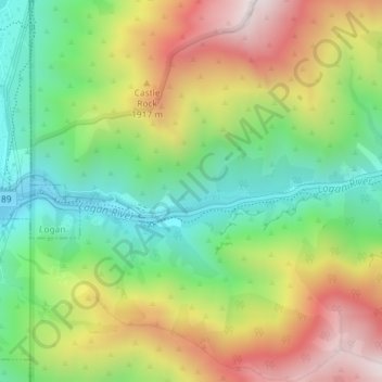
Name: Logan Canyon topographic map, elevation, terrain.
Location: Logan Canyon, Cache County, Utah, 84322, United States (41.73367 -111.77968 41.75367 -111.75968)
Average elevation: 1,780 m
Minimum elevation: 1,428 m
Maximum elevation: 2,253 m
Make a donation
Gear up for your next adventure:
As an Amazon Associate, this site earns from qualifying purchases at no extra cost to you.
Other topographic maps
Click on a map to view its topography, its elevation and its terrain.
Logan
United States > Utah > Cache County
The city lies near the eastern edge of Cache Valley on the western slopes of the Bear River Mountains. Mount Logan rises to an elevation of 9,710 feet (2,960 m) immediately to the east, and south of Logan Canyon. The eastern portions of the city are constructed on top of shelf-like "benches", late Pleistocene…
Average elevation: 1,498 m
Make a donation
Gear up for your next adventure:
As an Amazon Associate, this site earns from qualifying purchases at no extra cost to you.
Make a donation
Gear up for your next adventure:
As an Amazon Associate, this site earns from qualifying purchases at no extra cost to you.
Logan
United States > Utah > Cache County
The city lies near the eastern edge of Cache Valley on the western slopes of the Bear River Mountains. Mount Logan rises to an elevation of 9,710 feet (2,960 m) immediately to the east, and south of Logan Canyon. The eastern portions of the city are atop shelf-like "benches", late Pleistocene sedimentary…
Average elevation: 1,498 m
Make a donation
Gear up for your next adventure:
As an Amazon Associate, this site earns from qualifying purchases at no extra cost to you.