
Warri South-West topographic map
Interactive map
Click on the map to display elevation.
About this map
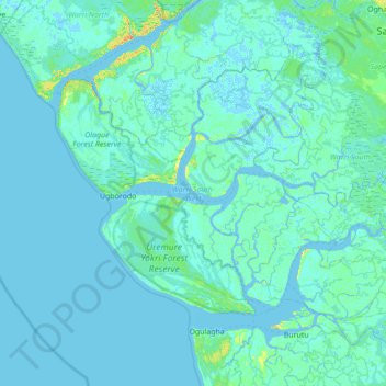
Name: Warri South-West topographic map, elevation, terrain.
Location: Warri South-West, Delta State, Nigeria (5.38082 5.09732 5.82965 5.78852)
Average elevation: 2 m
Minimum elevation: -3 m
Maximum elevation: 24 m
Other topographic maps
Click on a map to view its topography, its elevation and its terrain.
Warri
Nigeria > Delta State > Warri South
Warri, Warri South, Delta State, 332104, Nigeria
Average elevation: 4 m
Ughelli
Nigeria > Delta State > Ughelli North
Ughelli, Ughelli North, Delta State, Nigeria
Average elevation: 9 m
Asaba
Nigeria > Delta State > Oshimili South
Asaba, Oshimili South, Delta State, Nigeria
Average elevation: 62 m