
Thank you for supporting this site ❤️
Make a donation
Make a donation
Gear up for your next adventure:
As an Amazon Associate, this site earns from qualifying purchases at no extra cost to you.
Vaqueria topographic map
Click on the map to display elevation.
Thank you for supporting this site ❤️
Make a donation
Make a donation
Gear up for your next adventure:
As an Amazon Associate, this site earns from qualifying purchases at no extra cost to you.
About this map
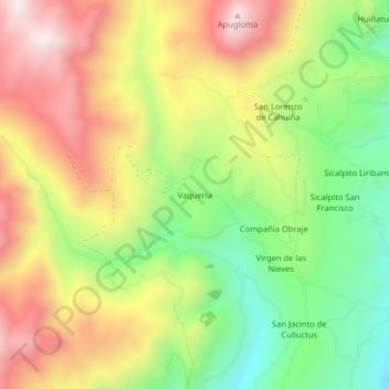
Name: Vaqueria topographic map, elevation, terrain.
Location: Vaqueria, Cajabamba, Colta, Chimborazo, 060410, Ecuador (-1.71216 -78.83276 -1.67216 -78.79276)
Average elevation: 3,707 m
Minimum elevation: 3,375 m
Maximum elevation: 4,060 m
Thank you for supporting this site ❤️
Make a donation
Make a donation
Gear up for your next adventure:
As an Amazon Associate, this site earns from qualifying purchases at no extra cost to you.