
Libertad topographic map
Click on the map to display elevation.
About this map
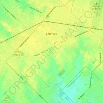
Name: Libertad topographic map, elevation, terrain.
Location: Libertad, Partido de Merlo, Buenos Aires, 1716, Argentina (-34.74711 -58.72201 -34.67818 -58.63621)
Average elevation: 27 m
Minimum elevation: 14 m
Maximum elevation: 35 m
Other topographic maps
Click on a map to view its topography, its elevation and its terrain.
José León Suárez
Argentina > Buenos Aires > José León Suárez > José León Suárez
Average elevation: 17 m
Ingeniero Maschwitz
Argentina > Buenos Aires > Ingeniero Maschwitz > Ingeniero Maschwitz
Average elevation: 10 m