Geolocate

Bradfield topographic map

Click on the map to display elevation.

About this map

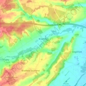
Name: Bradfield topographic map, elevation, terrain.

Location: Bradfield, West Berkshire, England, United Kingdom (51.42351 -1.17739 51.47425 -1.09847)

Average elevation: 77 m

Minimum elevation: 45 m

Maximum elevation: 121 m

Other topographic maps

Click on a map to view its topography, its elevation and its terrain.

Easton

United Kingdom > England > West Berkshire

Average elevation: 123 m

Shaw

United Kingdom > England > West Berkshire

Average elevation: 93 m

Mortimer

United Kingdom > England > West Berkshire > Mortimer

Average elevation: 80 m

Gear up for your next adventure:

🥾Approach Boots - Comfortable boots for hiking and climbing approaches
🧢Outdoor Cap - Protective cap for sun and rain during hikes
🎒Hiking Backpack - Lightweight and ergonomic backpacks for day hikes or multi-day treks
🥾Trail Hiking Socks - Comfortable socks to prevent blisters and fatigue
🌡️Emergency Mylar Blankets - Compact thermal protection for unexpected nights outdoors

As an Amazon Associate, this site earns from qualifying purchases at no extra cost to you.