Geolocate

Meirama topographic map

Click on the map to display elevation.

About this map

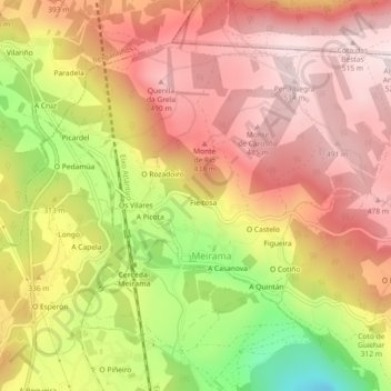
Name: Meirama topographic map, elevation, terrain.

Location: Meirama, Cerceda, Ordes, A Coruña, Galicia, Spain (43.20049 -8.45924 43.22652 -8.41377)

Average elevation: 337 m

Minimum elevation: 44 m

Maximum elevation: 519 m

Other topographic maps

Click on a map to view its topography, its elevation and its terrain.

Hospital

Spain > Galicia > Ordes

Average elevation: 404 m

O Canedo

Spain > Galicia > Ordes

Average elevation: 376 m

Cruz de Nouche

Spain > Galicia > Ordes > Beán

Average elevation: 312 m

Meitufe do Medio

Spain > Galicia > Ordes > Ordes

Average elevation: 383 m

Gear up for your next adventure:

🔋Emergency Crank Radio - Weather alerts and power without needing batteries
🥾Lightweight Hiking Boots - Boots for comfort and mobility on long hikes
🌬️Windproof Camp Stove - Efficient cooking even on exposed mountain peaks
🔋Solar Power Bank - Keep your GPS and devices charged during long outdoor trips
🔦LED Headlamp - Hands-free lighting for early morning starts or late finishes

As an Amazon Associate, this site earns from qualifying purchases at no extra cost to you.