
Thank you for supporting this site ❤️
Make a donation
Make a donation
Gear up for your next adventure:
As an Amazon Associate, this site earns from qualifying purchases at no extra cost to you.
Cul-des-Sarts topographic map
Click on the map to display elevation.
Thank you for supporting this site ❤️
Make a donation
Make a donation
Gear up for your next adventure:
As an Amazon Associate, this site earns from qualifying purchases at no extra cost to you.
Cul-des-Sarts
Cul-des-Sarts est situé entre 320 (à l'ancienne douane) et 375 mètres d'altitude (au lieu-dit Malgré-Tout - à la sortie du village vers Couvin). Le centre du village, là où se trouve l'église, s'élève à 363 mètres.
Thank you for supporting this site ❤️
Make a donation
Make a donation
Gear up for your next adventure:
As an Amazon Associate, this site earns from qualifying purchases at no extra cost to you.
About this map
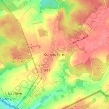
Name: Cul-des-Sarts topographic map, elevation, terrain.
Average elevation: 352 m
Minimum elevation: 311 m
Maximum elevation: 377 m
Thank you for supporting this site ❤️
Make a donation
Make a donation
Gear up for your next adventure:
As an Amazon Associate, this site earns from qualifying purchases at no extra cost to you.