Geolocate

Upper Egypt topographic map

Click on the map to display elevation.

About this map

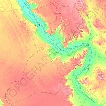
Name: Upper Egypt topographic map, elevation, terrain.

Location: Upper Egypt, New Valley, Egypt (25.00000 31.00000 27.00000 33.00000)

Average elevation: 314 m

Minimum elevation: 51 m

Maximum elevation: 789 m

Other topographic maps

Click on a map to view its topography, its elevation and its terrain.

Toshka

Egypt > New Valley

Average elevation: 197 m

Toshka

Egypt > New Valley

Average elevation: 194 m

Toshka

Egypt > New Valley

Average elevation: 196 m

Toshka Lakes

Egypt > New Valley

Average elevation: 162 m

White Desert

Egypt > New Valley

Average elevation: 170 m

Al Khargah City

Egypt > New Valley

Average elevation: 69 m

Jouhayna City

Egypt > New Valley

Average elevation: 66 m

Al Khargah City

Egypt > New Valley

Average elevation: 69 m

Al Khargah City

Egypt > New Valley

Average elevation: 69 m

Gear up for your next adventure:

🥾Trail Hiking Boots - Supportive boots for rough trails
🍽️Titanium Camping Spork - Ultralight and indestructible eating utensil
Camping Essentials - All-in-one gear for a comfortable camping trip
🕯️Camping Lantern - Illuminates your entire campsite with high-efficiency LEDs
🛶Canoe Life Vest - Safety vest for water sports

As an Amazon Associate, this site earns from qualifying purchases at no extra cost to you.