
Beattock topographic map
Interactive map
Click on the map to display elevation.
About this map
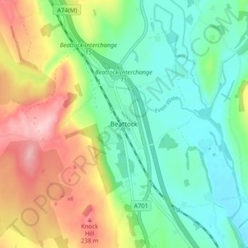
Name: Beattock topographic map, elevation, terrain.
Location: Beattock, Dumfries and Galloway, Écosse, DG10 9RB, Royaume-Uni (55.28443 -3.47162 55.32443 -3.43162)
Average elevation: 144 m
Minimum elevation: 80 m
Maximum elevation: 257 m
Other topographic maps
Click on a map to view its topography, its elevation and its terrain.
Beckfoot
Royaume-Uni > Écosse > Dumfries and Galloway > Annan
Beckfoot, Annan, Dumfries and Galloway, Écosse, DG12 6QZ, Royaume-Uni
Average elevation: 14 m
Langholm
Royaume-Uni > Écosse > Dumfries and Galloway
Langholm, Dumfries and Galloway, Écosse, DG13 0JQ, Royaume-Uni
Average elevation: 185 m