
Wiedlisbach topographic map
Click on the map to display elevation.
About this map
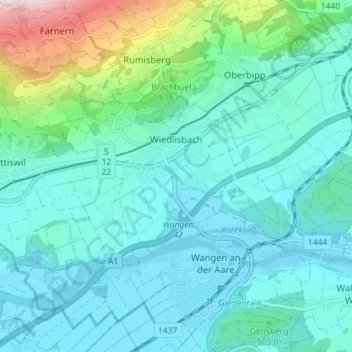
Name: Wiedlisbach topographic map, elevation, terrain.
Average elevation: 509 m
Minimum elevation: 416 m
Maximum elevation: 953 m
Other topographic maps
Click on a map to view its topography, its elevation and its terrain.
Gerbe
Switzerland > Bern > Oberaargau administrative district > Walterswil (BE)
Average elevation: 708 m
Rossweid
Switzerland > Bern > Oberaargau administrative district > Walterswil (BE)
Average elevation: 730 m