
Les Suchets topographic map
Interactive map
Click on the map to display elevation.
About this map
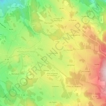
Name: Les Suchets topographic map, elevation, terrain.
Average elevation: 927 m
Minimum elevation: 783 m
Maximum elevation: 1,072 m
Other topographic maps
Click on a map to view its topography, its elevation and its terrain.
Montalivet
France > Auvergne-Rhône-Alpes > Haute-Loire > Montfaucon-en-Velay
Montalivet, Montfaucon-en-Velay, Yssingeaux, Haute-Loire, Auvergne-Rhône-Alpes, France métropolitaine, 43290, France
Average elevation: 901 m