
Thank you for supporting this site ❤️
Make a donation
Make a donation
Gear up for your next adventure:
As an Amazon Associate, this site earns from qualifying purchases at no extra cost to you.
Kaltohmfeld topographic map
Click on the map to display elevation.
Thank you for supporting this site ❤️
Make a donation
Make a donation
Gear up for your next adventure:
As an Amazon Associate, this site earns from qualifying purchases at no extra cost to you.
Kaltohmfeld
Der Ort Kaltohmfeld befindet sich am Ostrand des Ohmgebirgsplateaus, etwa fünf Kilometer nordöstlich von Worbis. Kaltohmfeld ist mit knapp 500 m Höhe das höchstgelegene Dorf des Eichsfeldes.
Thank you for supporting this site ❤️
Make a donation
Make a donation
Gear up for your next adventure:
As an Amazon Associate, this site earns from qualifying purchases at no extra cost to you.
About this map
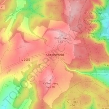
Name: Kaltohmfeld topographic map, elevation, terrain.
Average elevation: 468 m
Minimum elevation: 353 m
Maximum elevation: 534 m
Thank you for supporting this site ❤️
Make a donation
Make a donation
Gear up for your next adventure:
As an Amazon Associate, this site earns from qualifying purchases at no extra cost to you.