
Spechbach-le-Haut topographic map
Interactive map
Click on the map to display elevation.
About this map
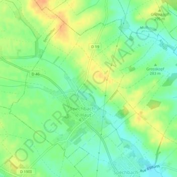
Name: Spechbach-le-Haut topographic map, elevation, terrain.
Average elevation: 281 m
Minimum elevation: 265 m
Maximum elevation: 299 m
Other topographic maps
Click on a map to view its topography, its elevation and its terrain.
Spechbach-le-Bas
France > Grand Est > Haut-Rhin > Spechbach
Spechbach-le-Bas, Spechbach, Altkirch, Haut-Rhin, Grand Est, France métropolitaine, 68720, France
Average elevation: 275 m